Egress rules across the Lineal Park were supposed to keep the Revival 629 Studio's LSB gate closed, except 11pm to 7am.
It's been open all the time now for quite a while (weeks? - months?) ...
.. And cyclists have already started using it as a safe route between the Lower Don Recreation Trail and the Eastern Avenue Bike Lanes.
New Cycling route through Revival 629 Studios avoids Carlaw
Northbound, take the west-side-of-the-building path up to Pape. Southbound you may choose to enter at the east gates (just west of Winnifred) and ride across the top to the west-side path
It's great! It avoids the nearby narrow, congested, ugly, dirty, dangerous, pot-holed Carlaw Avenue - excellently. :)
But what does it say about Small Blocks as a way to create livable neighbourhoods all along the South of Eastern study area generally, and the StudioCentre proposed development specifically?
Small Blocks are really important - but so far we haven't been successful at creating Complete Streets through intersections that cross Lake Shore Boulevard; part of that is political part of it is cultural - the other part is mechanical.
How do we create Complete Streets intersections at these new neighbourhood streets that cross a Grand Boulevard like Lake Shore Boulevard?:
I expect the answer is that we cannot have Grand Boulevards - don't need Grand Boulevards - of the type that we have now here in this Lake Shore Boulevard.
mh
Friday, August 29, 2014
Pt 3 - LSB/LDRT Intersection Hazards - Massing to the East of Logan
In Part 3 of the "LSB/LDRT Intersection Hazards" series, I get good video of drivers blocking the trail - at virtually every instance - as they try to make turns from southbound Logan onto westbound Lake Shore Boulevard.
In the second of these two video in Part 3, I look at the massing in driver's sightlines to the east of Logan that - in my opinion - is forcing drivers out across the trail in order to see to make their turns safely (for themselves and drivers on LSB anyway).
To conclude I present a possible fix for the driver sightlines problem.
LDRT/Logan - Driver Sightlines III - Turning drivers blocking the Trail
LDRT/Logan - Driver Sightlines IV - Massing to the east of Logan
Drivers turning westbound at Logan at Lake Shore Boulevard have to block the LDRT with their vehicles in order to get a clear view of oncoming traffic because in this observers opinion, their sightlines are blocked by a variety of fairly thin objects that together, mass to create a visual barrier as they try to understand the rate of approach of westbound LSB traffic.
This visual barrier complicates an already complicated intersection - which includes an east-west recreation trail, a railway line, and fast-moving highway traffic from the east.
May we suggest moving the trail as far south as far as possible; removing the 16 inch concrete barrier between the trail and the rail spur; moving the trees to the north side of the trail (into a bioswale construct please).
In this amateur planners' opinion, this would move the trail about a metre south, and at the same time clear driver's sightlines right where they would need to stop to avoid blocking the Trail. As well, the trees are suffocating right next to the roadway because of the carbon dioxide, ozone and the carbon monoxide massing there; moving them 3 metres away into a bioswale, might create vigorous growth - rather than a maintenance bill to replace them regularly.
mh
Thursday, August 28, 2014
Pt 2 - LSB/LDRT Intersection Hazards - Driver Sightlines
Conflicts between Drivers and Lower Don Recreation Trail users at Lake Shore Boulevard and the neighbourhood streets running north-south out of South Riverdale - Morse St, Logan St and Booth St - are the usual coarse of events when motor vehicle drivers try to make the dangerous and heart pounding merge onto the fast Lake Shore Boulevard.
The specific behaviour that is causing the perception amoungst cyclists that these are really dangerous places, is the vast majority of driver's habit of nosing into the Lower Don Recreation Trail (or completely blocking it) almost every time drivers make turns onto the LSB at these three intersections.
I watched for an hour and a half as drivers - confronted with so many vectors (and different qualities of vectors - cyclists at one set of speeds, joggers and at another speed) actually make mistakes - and force cyclists to brakes or steer evasively to avoid being hit as the driver slams on their brakes also - just in time to avoid collisions.
In these two videos I use the camera to imitate how a driver in a car sees the intersection, by standing where a driver would be seated with their car stopped at various places - behind the stop line; halfway into the Trail; and right across the trail - in order to understand what's going on:
LDRT/Logan - Driver Sight Lines I 2014/08/27 6 39pm
A multitude of sign posts to the east of the Logan/LDRT intersection blocks driver's sightlines to the east - obscuring high speed motor vehicle traffic speeding off the light at Carlaw. This seems to be the reason drivers are moving forward such that they block the entire width of the Lower Don Recreation Trail here as they try to make their turns westbound onto the Lake Shore Boulevard.
In the second of these videos I talk about a great conversation I had with a driver, a resident nearby, who noted a West sight lines issue that I hadn't seen. From a driver's point of view, a fence blocks their view of cyclists coming eastbound towards the intersection:
LDRT/Logan - Driver Sight Lines II 2014/08/27 7:21pm
A fence to the west of the Logan/LDRT intersection blocks driver's sightlines to the west - obscuring cyclists coming eastbound on the LDRT. This seems to be one of the reasons drivers are nosing halfway across the Lower Don Recreation Trail here as they try to make their turns westbound onto the Lake Shore Boulevard.
mh
The specific behaviour that is causing the perception amoungst cyclists that these are really dangerous places, is the vast majority of driver's habit of nosing into the Lower Don Recreation Trail (or completely blocking it) almost every time drivers make turns onto the LSB at these three intersections.
I watched for an hour and a half as drivers - confronted with so many vectors (and different qualities of vectors - cyclists at one set of speeds, joggers and at another speed) actually make mistakes - and force cyclists to brakes or steer evasively to avoid being hit as the driver slams on their brakes also - just in time to avoid collisions.
In these two videos I use the camera to imitate how a driver in a car sees the intersection, by standing where a driver would be seated with their car stopped at various places - behind the stop line; halfway into the Trail; and right across the trail - in order to understand what's going on:
PART I
LDRT/Logan - Driver Sight Lines I 2014/08/27 6 39pm
A multitude of sign posts to the east of the Logan/LDRT intersection blocks driver's sightlines to the east - obscuring high speed motor vehicle traffic speeding off the light at Carlaw. This seems to be the reason drivers are moving forward such that they block the entire width of the Lower Don Recreation Trail here as they try to make their turns westbound onto the Lake Shore Boulevard.
PART II
In the second of these videos I talk about a great conversation I had with a driver, a resident nearby, who noted a West sight lines issue that I hadn't seen. From a driver's point of view, a fence blocks their view of cyclists coming eastbound towards the intersection:
LDRT/Logan - Driver Sight Lines II 2014/08/27 7:21pm
A fence to the west of the Logan/LDRT intersection blocks driver's sightlines to the west - obscuring cyclists coming eastbound on the LDRT. This seems to be one of the reasons drivers are nosing halfway across the Lower Don Recreation Trail here as they try to make their turns westbound onto the Lake Shore Boulevard.
mh
Wednesday, August 27, 2014
Eastern Ave Bike Lanes: 'They Don't Go Anywhere!'
2014/08/27 7:26pm
A politician who is running for Councillor in Ward 30 has made a video1 (shot about right here) about how the Eastern Avenue Bike Lanes 'Don't go Anywhere'
Eastern Ave Bike Lanes: 'They Don't Go Anywhere!'
As the video says, "Well, actually they go to the Contraflow Lane on Logan Ave which gets you further westbound via the Lower Don Recreation Trail which gets you to Queen's Quay"
.. and access to the East Downtown, the Financial District and the Fashion District and Queen West and Parkdale.
(Beware the crossing at Cherry St/LSB, which is a high speed chicane and then wait for a spot and RUN! Then beware the ongoing construction on Queen's Quay all the way to Bathurst.)
But point taken. Eastern Avenue past Logan leads to the Eastern Avenue Bridge just past Broadview - which is partly an off-ramp for the DVP southbound - and is also constructed just like a 400 series highway ramp - so wide lanes and a very high speed traffic. Plus it has an off-ramp for north bound DVP off the eastbound lanes of the bridge at the eastern end of it; plus it has merging lanes at it's apex which connect it to Adelaide eastbound, and to Richmond westbound.
I don't see a way that it can be fixed (made a Complete Street).
So, candidates that want to be Councillor of Ward 30 need to be asked the question:
Should we extend the Bike Lanes on Eastern over to Broadview? Do we build a cyclist's pedestrian bridge off the end of Sunlight Park Road over to Corktown Common (that would connect to the planned Richmond/Adelaide cycling corridor)?
And because the approaches to that route are private property owned by First Gulf, part of the Leaver site - do we then therefore have to go with a short-term fix until that development package is sorted out, and put Bike Lanes on Broadview?
At a minimum, to create a sort-of-OK bike-commute-route network - we need Bike Lanes on Broadview up to the Dundas Bike Lanes.
Or do we face the facts and tear down the Eastern Avenue Bridge, and start over?
Hard Choices. Will these realities help move the conversation forward that often doesn't go anywhere around real cycling infrastructure - transportation issues in general - in the GTA?
I hope so.
1Youtube Channel - Liz West - A Better Network of Bike Lanes - http://youtu.be/r14kfe-mZsw
NOTE:
The Eastern Avenue Bike Lanes go from Leslie to Logan - that's twelve neighbourhood blocks (not four); and - if we separated the Eastern Avenue Bike Lanes form the traffic lanes - it would connect Bruce Junior Public School and Morse Street Jr Public School to the neighbourhoods.
mh
LSB/LDRT Intersection Hazards
LSB/LDRT Intersection Hazards
.. I end with "..it's a big problem ... at Morse..." - and I go on to say (as my battery over-heats) - 'at Logan and Booth.'
That is - Conflicts between Drivers and Trail Users - where the motor vehicle drivers are nosing into the Lower Don Recreation Trail (or completely blocking it) as they try to make a dangerous and heart pounding merge onto the fast Lake Shore Boulevard from these small side streets.
In some cases I watched as the driver, confronted with so many vectors - and different qualities of vectors (cyclists at one set of speeds, joggers and at another speed...) - that they actually make mistakes and force cyclists to slam on their brakes of steer evasively to avoid being hit as the driver slams on their brakes just in time.
More videos on this are coming right up.
I spent 2 hours at Logan/LSB/LDRT tonight (Wednesday, August 27, 2014) between when this video was shot( at 5:24 pm) til about 7:30pm.
I saw the switch from commute cyclists dominating the traffic pulses along the LDRT, to recreation cyclists dominating the flows. The numbers never decreased. And all the while, motor vehicle traffic maintained a steady volume - both on the Lake Shore Boulevard and motor vehicle drivers using Logan southbound to get onto the LSB.
Very interesting.
Thinking that making Logan a through-street down to Commissioners with a signaled intersection at LSB, might be the best way to solve all this.
'Almosts' (bikes getting almost hit by cars) happen every few minutes at Logan. At the signaled intersections - like Carlaw - 'almosts' happen *just* once an hour. :\
mh
Thursday, August 21, 2014
@TCATonline 'Difference between infrastructure merchants think visitors want and what they want, substantial'
TCAT just released a study on the impact of bike lanes on Danforth businesses.
A summary of the findings:
From: Toronto Centre for Active Transportation - Thu, Aug 7, 2014
"Bike Lanes, On-Street Parking and Business: A Study of Danforth Avenue in Toronto Danforth Neighbourhood"
http://tcat.ca/node/2383
Via Val Dodge of Ward 29 Bikes
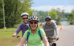
Bells on Danforth is on Sunday, September 14th this year - starting as usual at East Lynn Park at 12:30pm. Bring the whole family to this marshaled ride on the Danforth to Nathan Phillips Square for "Bikestock" - a fun, entertaining celebration of cycling.
A marshaled, Return Ride to East Lynn Park is available.
Twitter: https://twitter.com/BellsOnDanforth
Facebook: https://www.facebook.com/bellsondanforth
mh
A summary of the findings:
- Less than 1 out of 5 visitors drive to the Danforth
- Merchants overestimate the importance of drivers to their business, and underestimate the importance of cyclists
- Those who live or work in the area visit the Danforth more frequently than those who do not: 78% of those who live in the are visit more than five times per month whereas only 23% of those who do not live or work in the area visit more than five times per month
- Those who live or work in the area spend more money than those who do not: 62% of those who live in the are spend over $100 per month whereas only 10% of those who do not live or work in the area spend over $100 per month
- Those who walk to the Danforth are much more likely to spend more money that those who drive or take public transit: 67% of those who walk spend over $100 per month whereas only 14% of those who take public transit and 31% of those who drive spend over $100 per month
- The difference between the infrastructure merchants want for visitors, and what visitors say they want is substantial; merchants favour increased parking, but more parking was their customer’s lowest priority
- Survey respondents who reported spending over $300 or more in a typical month in the neighbourhood preferred street changes that included bike lanes and reduced on street parking
- Overall the majority of people surveyed (71%) preferred to see street use reallocated for widened sidewalks or a bike lane. Support was only slightly higher for those who live in the area (72%) than those who don’t (69%). Looking at preference by mode of transportation, the highest support for change was found amongst people who take public transit to the Danforth (77%), followed by those who walk to the area (72%). Interestingly, even the majority of drivers (59%) would prefer streetscape changes.
From: Toronto Centre for Active Transportation - Thu, Aug 7, 2014
"Bike Lanes, On-Street Parking and Business: A Study of Danforth Avenue in Toronto Danforth Neighbourhood"
http://tcat.ca/node/2383
Via Val Dodge of Ward 29 Bikes
Bells on Danforth is on Sunday, September 14th this year - starting as usual at East Lynn Park at 12:30pm. Bring the whole family to this marshaled ride on the Danforth to Nathan Phillips Square for "Bikestock" - a fun, entertaining celebration of cycling.
A marshaled, Return Ride to East Lynn Park is available.
Bells on Danforth 2014:
Web - http://bellsondanforth.ca/2014/06/23/bells-on-danforth-2014-sunday-september-14/Twitter: https://twitter.com/BellsOnDanforth
Facebook: https://www.facebook.com/bellsondanforth
mh
Tuesday, August 12, 2014
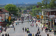
First @OpenStreetsTO happens this Sunday, August 17th - 8am to 12noon!
Come walk, bicycle, sit, play, wander, even snooze - on Bloor Street, and on Youge Street - from 8am - 12noon on Sunday, August 17th.
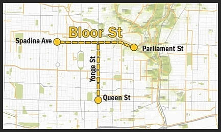
Your next opportunity to experience our urban built form not dominated by motor vehicle traffic noise, stress and rage happens two weeks later same human streets same human hours - on Sunday, August 31th.
Think of a play opportunity you can organize.
- Divide up into teams for street hockey, soccer, stick-ball!
- Lay down a blanket and some pillows and have a picnic!
- Bring patio furniture and an umbrella - set it up in front of some of your musician friends who have organized a music set!
- Get on your bike that you've had in storage since the week after you bought it - and experience the wind in your hair as you human-power yourself around the city's core to your destination!.
Think WAY outside the box - Or not ...
But come! And experience this urban place set aside for people - rather than traffic.
Open Streets TO:
Web - http://www.openstreetsto.org/Twitter - https://twitter.com/OpenStreetsTO
Facebook - https://www.facebook.com/openstreetsto
Images served from www.openstreetsto.org
mh
Saturday, August 9, 2014
Checking the Road Closed construction detouring for Cyclists at Eastern & Mosley
Video - Saturday, August 9, 2014 - 1:07pm
Checking the Road Closed construction detouring for Cyclists at Eastern & Mosley
The latest Leslie Street TTC street reconstruction configuration closes the intersection of Eastern and Leslie until September 7, 2014.
The Road Closed detouring for cyclists on Eastern Avenue at Mosley St was non-existent (as usual) when the new configuration was installed on July 28th.
After two independent walkabouts to study the way road users were using the spaces on July 28th1 and on August 6th2 - plus a @TTCLeslieBarns planned Safety Walk on the evening of August 6th, we now have a pretty good detour configuration for Cyclists.
Thanks go to Ward 30 Toronto-Danforth Councillor Paula Fletcher, who attended the Safety Walk on August 6th; to @TTCLeslieBarns who transmitted the idea concisely and quickly; and to Pomerleau Construction, who executed it perfectly.
Ward 30 Bikes was very disappointed that TTC ignored ideas that they asked us for at the last Community Liaison Group meeting on ways to implement cycling detour routes around the closed intersection on residential streets - detour route signage aimed specifically at cyclists that would have been separate routes from Transportation's suggested detour routes for cars (which are always on main arterial streets).
So - we invited Councillor Paula Fletcher to come to the Safety Walk that was supposed to review all the stuff TTC said they were going to do, but didn't (or couldn't) do.
As some background on this - the present road closure is at Moeley and at Leslie - this is resulting in road users using the Plaza Parking Lots as a detour route. This is mixing cars and trucks and cyclists and pedestrians in a narroew conjested and badly signed areas that are not edesigned to act as roadways - they are parking lots not streets.
The safe way to close this intersection is: - on the west side - Close Eastern at Pape with an egress point for local traffic. On the east side - the last arterial avenue is Coxwell - Eastern should have been closed there with an egress point for local access.
Much pressure from local businesses along this stretch has caused the TTC to do what they've done. The feedback their getting from business is that the businesses would rather have the egress through and by their stores in a congested and dangerous way - so that impulse consumerism will create shopping opportunities for people caught in tha chaos at their front doors.
As I put it to a TTC Leslie Barns representative during the Safety Walk - so your putting consumerism over road user safety?
That what is exactly what they've done.
So thinking on our feet we instead advocated for better detour infrastructure that would encourage cyclists to stay out of the Plaza Parking Lots:
The FreshCo and Loblaws parking Lots are in fact the defacto detour route due to the road closure configuration that TTCLeslie Barns is facilitating by not blocking eastbound Eastern at Pape and westbound Eastern at Coxwell. If they had done that the added benifit would have been safe cyclists routes around Leslie Eastern on Queen and lessened motor vehicle impacts on residential streets north off of Eastern - like at Rushbrooke to West which is getting hammered and at Laing to the East which has been getting halmmer since trhis started in September of 2013 - for example.
So now Ward 30 Bikes suggests that you take the good Bike Lane detouring now open at Mosley and Eastern, and cycle through the Road Closed signage and continue through to LeslieStreet where you should dismount for the short pedestrian walkway that is open on the south side of the intersection there at this time (due to close at some point in the construction phase).
1 Facebook Ward 30 Bikes Page - August 1, 2014 | Cycling Issues - Eastern Avenue Closure (July 28th walkabout) | https://www.facebook.com/ward30bikes/posts/627966513983953
2 Ward 30 Bikes - Wednesday, August 6, 2014 | Another Walkabout of the Eastern Avenue Closure at Leslie Street | http://ward30bikes.blogspot.ca/2014/08/another-walkabout-of-eastern-avenue.html
mh
Checking the Road Closed construction detouring for Cyclists at Eastern & Mosley
The latest Leslie Street TTC street reconstruction configuration closes the intersection of Eastern and Leslie until September 7, 2014.
The Road Closed detouring for cyclists on Eastern Avenue at Mosley St was non-existent (as usual) when the new configuration was installed on July 28th.
After two independent walkabouts to study the way road users were using the spaces on July 28th1 and on August 6th2 - plus a @TTCLeslieBarns planned Safety Walk on the evening of August 6th, we now have a pretty good detour configuration for Cyclists.
Thanks go to Ward 30 Toronto-Danforth Councillor Paula Fletcher, who attended the Safety Walk on August 6th; to @TTCLeslieBarns who transmitted the idea concisely and quickly; and to Pomerleau Construction, who executed it perfectly.
Ward 30 Bikes was very disappointed that TTC ignored ideas that they asked us for at the last Community Liaison Group meeting on ways to implement cycling detour routes around the closed intersection on residential streets - detour route signage aimed specifically at cyclists that would have been separate routes from Transportation's suggested detour routes for cars (which are always on main arterial streets).
So - we invited Councillor Paula Fletcher to come to the Safety Walk that was supposed to review all the stuff TTC said they were going to do, but didn't (or couldn't) do.
As some background on this - the present road closure is at Moeley and at Leslie - this is resulting in road users using the Plaza Parking Lots as a detour route. This is mixing cars and trucks and cyclists and pedestrians in a narroew conjested and badly signed areas that are not edesigned to act as roadways - they are parking lots not streets.
The safe way to close this intersection is: - on the west side - Close Eastern at Pape with an egress point for local traffic. On the east side - the last arterial avenue is Coxwell - Eastern should have been closed there with an egress point for local access.
Much pressure from local businesses along this stretch has caused the TTC to do what they've done. The feedback their getting from business is that the businesses would rather have the egress through and by their stores in a congested and dangerous way - so that impulse consumerism will create shopping opportunities for people caught in tha chaos at their front doors.
As I put it to a TTC Leslie Barns representative during the Safety Walk - so your putting consumerism over road user safety?
That what is exactly what they've done.
So thinking on our feet we instead advocated for better detour infrastructure that would encourage cyclists to stay out of the Plaza Parking Lots:
 |
| Sketch submitted to TTC Leslie Barns - August 7, 2014 |
The FreshCo and Loblaws parking Lots are in fact the defacto detour route due to the road closure configuration that TTCLeslie Barns is facilitating by not blocking eastbound Eastern at Pape and westbound Eastern at Coxwell. If they had done that the added benifit would have been safe cyclists routes around Leslie Eastern on Queen and lessened motor vehicle impacts on residential streets north off of Eastern - like at Rushbrooke to West which is getting hammered and at Laing to the East which has been getting halmmer since trhis started in September of 2013 - for example.
So now Ward 30 Bikes suggests that you take the good Bike Lane detouring now open at Mosley and Eastern, and cycle through the Road Closed signage and continue through to LeslieStreet where you should dismount for the short pedestrian walkway that is open on the south side of the intersection there at this time (due to close at some point in the construction phase).
References:
1 Facebook Ward 30 Bikes Page - August 1, 2014 | Cycling Issues - Eastern Avenue Closure (July 28th walkabout) | https://www.facebook.com/ward30bikes/posts/627966513983953
2 Ward 30 Bikes - Wednesday, August 6, 2014 | Another Walkabout of the Eastern Avenue Closure at Leslie Street | http://ward30bikes.blogspot.ca/2014/08/another-walkabout-of-eastern-avenue.html
mh
Thursday, August 7, 2014
Masters of Industry: South Riverdale to be the new West-of-Spadina High-rise Tower Goldmine
Finance - Industry would line East Waterfront with Highrise Condo Towers from Don River to Woodbine.
By Michael Holloway
Streetcar Developments - the developer who bought Jilly's - and is voluntarily including low income units in their plan for the remodeling of the property - have also acquired a 4 acre site between Eastern and Queen along the Don Roadway, a project they're calling "Riverside Square".
 |
| Streetcar Developments Site Context drawing - Cycling Connections |
It's not Mid-rise - it's Highrise - and it's a good indication why the developer did the 'loss-leader' thing about the low income units at the Jillys' proposed development. A little good-will goes a long way (a long way Up - in this case).
Jillys' is the 'Hi how are ya?'
The three, 7, 13 and 24 story towers are the,
'I'm your new neighbour (with the three loud barking dogs).'
But in case, the new neighbour with the loud dogs didn't just buy the house next door - they bought the whole block, and all the blocks in a 1/2km radius!
Welcome to the neighbourhood - I guess...
The good news is this company gets the Complete Streets and Sustainable Transportation part that going up 22 stories necessitates (that Mid-rise on the Avenues necessitates for that matter).
Quoting a recent letter to the Broadview/Queen Community:
"Given the scale and location of Riverside Square we see great opportunity to make much needed bike and pedestrian connections across the Don River to Corktown Common, provide new green space and perhaps most importantly: reintegrate the site into the traditional mixed-use character of the Queen East while providing valuable new services and publicly accessible amenities to the community."
Just so we're all on the same page on this - the elites, the establishment of this country - the banks, the financial institutions and their governments - are out of room on the West of Spadina side of Toronto's downtown - there's no room in South Parkdale - they can't build along the bottom of High Park
And so mark my words - and this development proposal and the First Gulf Leaver site proposal (that visions a Second City Centre anchored by a World Trade Center style array of towers) are the indicators - South Riverdale (and the new Lower South Riverdale, the Port Lands), is the new West-of-Spadina.
The functioning of greed and powerful special interest is visioning miles and miles of lake front highrise towers made of ticky-tacky* - all the way to Woodbine. A wall of private development that will create a another barrier to the water at the Lake front - a barrier to all but those who buy south-facing concrete cubicals (with windows that don't open).
Information link (via Paul Young newsletter) Spring Realty inc. | "Streetcar Plans Largest Development in Riverside History" | http://springrealty.ca/?breaking-news-streetcar-plans-largest-development-in-riverside-history.&p=5340
References:
Streetcar Developments | Riverside Square | http://streetcar.ca/welcome-riverside-square/
* 'tickey-tacky'? --> Pete Seeger - Little Boxes
mh
Wednesday, August 6, 2014
Another Walkabout of the Eastern Avenue Closure at Leslie Street
Wednesday, August 6, 2014 - 12noon to 2pm
I bicycled both eastbound and westbound approaches, and walked the entire site - with special attention paid to the immediate area of Eastern at Leslie.
One just before Pape, indicates that Pape Avenue is open northbound.
The Larchmount intersection has a northbound left-turn lane and is signaled. After this point the chicane begins making lane changes and left turns, very dangerous.
I concluded that Larchmount is safest Northbound Cyclist's Detour Route.
On the walkabout portion of the site visit I noted, now ten days into the Closure of Eastern at Leslie - that Rushbrooke is still receiving traffic as a result of a large number of 'emergency' exits off of Eastern - as motorists become aware of the closure just before they get to Rushbrooke. As a result of this surprise situation the Rushbrooke/Mosley/Eastern area is a mass of confusion with vehicles doing U-Turns and stopping short and making sudden turns without looking or signaling. This is further complicated by Traffic Pulses of Cars Exiting the FreshCo Lot - which they are using along with the Loblaws Lot, as a Eastern Avenue Closure Detour Route.
95% of road users on Eastbound Eastern are turning southbound at Mosley and going through the FreshCo/Loblaws Parking lots and back onto Eastern via the east-side Loblaws driveway.
I noted 14 Cyclist road users while at this observation point; 1 of the 14 went straight through and crossed Leslie via the pedestrian walkway on the south side of the intersection (after coming into conflict with a car at the corner of Mosley as she decided to go straight through).
Signs on Eastern Avenue, East of the Closure are same as in the opposite direction; but no 'last-chance' sign (as near Pape Ave).
Drivers traveling Westbound along Eastern can see the closure from about 400 metres east of the intersection (past their last exit at Laing) - as a result they are taking the East and West Entrances to the Loblaws Lot and using the parking lot driveway along the North edge to Exit back onto Easter in the opposite direction.
As 'Traffic Pulses' of Cars are coming up the East delivery-way lane - there is some congestion and confusion as people aren't sure where they are allowed to drive. Some try to go southbound along the delivery-way lane which is a One-Way Northbound - as such the placement of the Traffic Guidance Officer at the Entrance/Exit is key.
Over about an hour of observing from both east and west vantage points, I saw 7 cyclists ride up the East-side sidewalk of Leslie North of Eastern Ave to Queen St. Later I walked it - it is a dirty, pot-holed, narrow, winding path --- there is not enough room to walk your bike up this route without coming into conflict with other users - avoid this route with a bike.
AND FOR GOD'S SAKE - DON'T RIDE IT!!!
I also note as above - that on this side of the Closure I recorded 10 Cyclist road users during my time there; 4 of whom were riding on the Eastern Avenue sidewalks (for safety I assume - on this wide, fast roadway with no bike lanes).
Cycling Westbound towards the Closure, I suggest getting off of Eastern at Knox or at Laing. Second most popular route seemed to be the Loblaws Parking Lot West-side driveway, down to the Plaza Intersection - where an Officer is directing all comers through the intersection.
After 10 days road-users still don't understand what's going on until the last minute as they approach the closure - this is leading to a dangerous mixing of modes especially in the Plaza Parking Lots - but also on the sidewalks in the area. Better signage and clearly marked detour routes for both motor vehicles and for cyclist users (separately) might help reduce dangerous mode mixing and user conflicts.
Perhaps the one simple thing that might accomplish the most good is the closure of Eastern Ave on either side of the closure (leave one lane open; posted Local Traffic Only) . Closing Eastern at Pape Avenue on the West side; and at Laing St on the East side - in this observers opinion - would greatly decrease the dangerous mixing of the three modes - especially in the Parking Lots and at their entrance-ways. This calming of the Plaza's Parking Lots might also draw off cyclists who feel too insecure to ride anything but the sidewalks in the present construction configuration.
A Map - with more notes from this walkabout:
Driving Conditions & Cyclist Detour Routes around Eastern/Leslie Closure
View Driving Conditions & Cyclist Detour Routes around Eastern/Leslie Closure in a larger map
mh
Leslie Street reconstruction Site-Walk Notes
I bicycled both eastbound and westbound approaches, and walked the entire site - with special attention paid to the immediate area of Eastern at Leslie.
Eastbound on Eastern from Booth to Leslie:
Signs say only "Eastern Closed at Leslie til Sept. 7th"One just before Pape, indicates that Pape Avenue is open northbound.
The Larchmount intersection has a northbound left-turn lane and is signaled. After this point the chicane begins making lane changes and left turns, very dangerous.
I concluded that Larchmount is safest Northbound Cyclist's Detour Route.
Inspection of the West-side road closure at Mosley & Eastern - 30 minutes:
On the walkabout portion of the site visit I noted, now ten days into the Closure of Eastern at Leslie - that Rushbrooke is still receiving traffic as a result of a large number of 'emergency' exits off of Eastern - as motorists become aware of the closure just before they get to Rushbrooke. As a result of this surprise situation the Rushbrooke/Mosley/Eastern area is a mass of confusion with vehicles doing U-Turns and stopping short and making sudden turns without looking or signaling. This is further complicated by Traffic Pulses of Cars Exiting the FreshCo Lot - which they are using along with the Loblaws Lot, as a Eastern Avenue Closure Detour Route.
95% of road users on Eastbound Eastern are turning southbound at Mosley and going through the FreshCo/Loblaws Parking lots and back onto Eastern via the east-side Loblaws driveway.
I noted 14 Cyclist road users while at this observation point; 1 of the 14 went straight through and crossed Leslie via the pedestrian walkway on the south side of the intersection (after coming into conflict with a car at the corner of Mosley as she decided to go straight through).
Westbound on Eastern from Queen/Kingston to Leslie:
Signs on Eastern Avenue, East of the Closure are same as in the opposite direction; but no 'last-chance' sign (as near Pape Ave).
Inspection of the East-side road closure at Leslie & Eastern - 30 minutes:
Drivers traveling Westbound along Eastern can see the closure from about 400 metres east of the intersection (past their last exit at Laing) - as a result they are taking the East and West Entrances to the Loblaws Lot and using the parking lot driveway along the North edge to Exit back onto Easter in the opposite direction.
As 'Traffic Pulses' of Cars are coming up the East delivery-way lane - there is some congestion and confusion as people aren't sure where they are allowed to drive. Some try to go southbound along the delivery-way lane which is a One-Way Northbound - as such the placement of the Traffic Guidance Officer at the Entrance/Exit is key.
Over about an hour of observing from both east and west vantage points, I saw 7 cyclists ride up the East-side sidewalk of Leslie North of Eastern Ave to Queen St. Later I walked it - it is a dirty, pot-holed, narrow, winding path --- there is not enough room to walk your bike up this route without coming into conflict with other users - avoid this route with a bike.
AND FOR GOD'S SAKE - DON'T RIDE IT!!!
I also note as above - that on this side of the Closure I recorded 10 Cyclist road users during my time there; 4 of whom were riding on the Eastern Avenue sidewalks (for safety I assume - on this wide, fast roadway with no bike lanes).
Cycling Westbound towards the Closure, I suggest getting off of Eastern at Knox or at Laing. Second most popular route seemed to be the Loblaws Parking Lot West-side driveway, down to the Plaza Intersection - where an Officer is directing all comers through the intersection.
Conclusions:
After 10 days road-users still don't understand what's going on until the last minute as they approach the closure - this is leading to a dangerous mixing of modes especially in the Plaza Parking Lots - but also on the sidewalks in the area. Better signage and clearly marked detour routes for both motor vehicles and for cyclist users (separately) might help reduce dangerous mode mixing and user conflicts.
Perhaps the one simple thing that might accomplish the most good is the closure of Eastern Ave on either side of the closure (leave one lane open; posted Local Traffic Only) . Closing Eastern at Pape Avenue on the West side; and at Laing St on the East side - in this observers opinion - would greatly decrease the dangerous mixing of the three modes - especially in the Parking Lots and at their entrance-ways. This calming of the Plaza's Parking Lots might also draw off cyclists who feel too insecure to ride anything but the sidewalks in the present construction configuration.
A Map - with more notes from this walkabout:
Driving Conditions & Cyclist Detour Routes around Eastern/Leslie Closure
View Driving Conditions & Cyclist Detour Routes around Eastern/Leslie Closure in a larger map
mh
Sunday, August 3, 2014
@PaulaFletcher30 to address Lower Don Accessibility Issue at Parks & Environment Committee, Friday, August 15
Councillor Fletcher, Ward 30 Toronto-Danforth, is petitioning at Committee to pass a motion asking for a study and a report-back on accessible connections to the neighbourhoods from the Lower Don Trail - at the Parks and Environment Committee meeting on Friday, August 15, 2014.
The Councillor will talk to concerns a group of us advocates raised this spring about the lack of Accessible Connections (Ramps) from the Bridges that cross the Don Valley down to the LDT below the Viaduct (Dundas, Gerrard and the Riverdale Park Pedestrian Bridge).
It sets the stage for a possible ramp build in the future - she's requesting that:
(quoting)
1) The City re-confirms its commitment to accessibility on the Lower Don Trail.
2) Further study be undertaken on potential points of access onto the Lower Don Trail in particular the pedestrian bridge joining Riverdale Park East and West.
3) Report to P and E in Q2, 2015 on the results.
.
The motion needs our community support.
You can write to the clerk in charge of communications for the Committee to make a written deputation right away - or you can request time on the agenda to speak to the issue on the 15th in Committee Room 1 at City Hall (meeting starts at 9am - meeting agenda is not yet posted).
Email the Committee: pec@toronto.ca
In the title of your email be sure to include this phrase:
"2014.PE29 - Re: Lower Don Trail Accessibility"
Secretariat Contact:
Carol Kaustinen
10th floor, West Tower, City Hall
100 Queen Street West
Toronto, ON M5H 2N2
email: pec@toronto.ca
phone: 416-338-5089
fax: 416-392-1879
TMMIS address for Parks and Environment Committee meeting of August 15, 2014 (Meeting 29): http://app.toronto.ca/tmmis/decisionBodyProfile.do?function=doPrepare&decisionBodyId=368#Meeting-2014.PE29
.
Michael Holloway
Ward 30 Bikes
Here's a copy of Councillor Fletcher's letter to the Committee:
July 23, 2014
Councillor Mammoliti and Members
Parks & Environment Committee
Dear Committee Members:
Re: Lower Don Trail Accessibility
The Lower Don Trail has limited accessibility from Queen Street to Danforth Avenue.
Currently there are stairs at Queen as well as the Riverdale foot bridge. While there is a trench to wheel a bicycle up and down the stairs it is awkward and cumbersome. Many riders simply carry their bikes up the stairs. Trail access and egress at these points is limited to those who can manage their bicycles on the steep incline.
As part of the Lower Don Trail Master Plan there will be two new stair entrances; one from Dundas and one from Gerrard onto the trail.
In May, I had a site meeting on the trail with staff from DTAH, TRCA, PFR and members of the cycling committee to review the Master Plan for the Lower Don trail and to see if the new stairway entrances at Gerrard and Dundas could be made more accessible for cyclists, and anyone with mobility issues. Both of the locations are on street car routes and of course our new street cars will be fully accessible.
Sadly, it was not deemed possible at either of these locations.
There remains a real need for an accessible point on the trail between Queen and Danforth and it was suggested that the pedestrian bridge from Riverdale Park East to West may be a good option.
I am requesting that:
- The City re-confirms its commitment to accessibility on the Lower Don Trail.
- Further study be undertaken on potential points of access onto the Lower Don Trail in particular the pedestrian bridge joining Riverdale Park East and West.
- Report to P and E in Q2, 2015 on the results.
Thank you for your consideration.
Sincerely,
Councillor Paula Fletcher, Ward 30
mh
Subscribe to:
Posts (Atom)