Leg #9
Don Roadway Boulevard (access under Railway bridge).
This is Lag #9 of a preliminary walk of the 21 Don Roadway site. See a list of all 10 Legs of this walkabout below, or at the link (also on the interactive Google Map - click on the drop-down menu - top-left, menu icon):
Ward 30 Bikes | A Map: 21 Don Roadway Walk-about - December 6, 2014 | http://ward30bikes.blogspot.ca/2014/12/a-map-21-don-roadway-walk-about.html
Connections North-South & East-West
First Gulf sketches of the site indicate a bicycle/pedestrian connection from the northwest corner of the site under the rail bridge, across the Don Valley to the Lower Don Trail on the west side of the valley near the Corktown Common Multi-use path tunnel.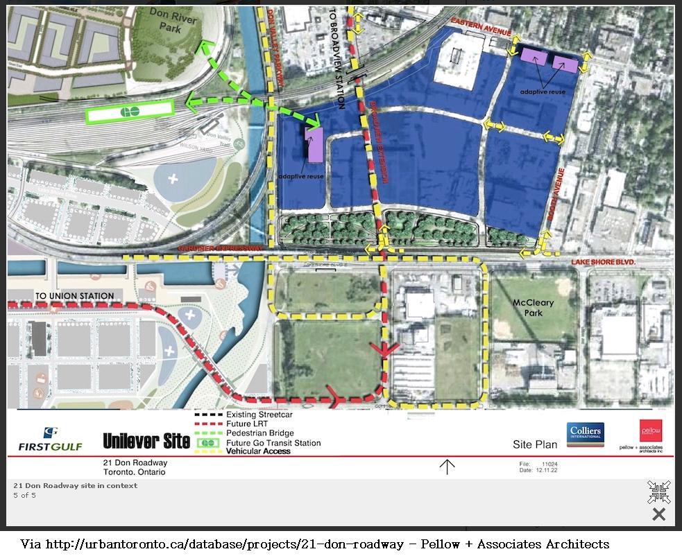 |
First Gulf/Pellow + Associates Architects/UrbanToronto - http://urbantoronto.ca/database/projects/21-don-roadway
|
Cyclists have been looking for an opportunity to create a connection north-south along the east side of the Don River from Queen Street down to the Port Lands. Beside the Don Roadway has always seemed like an obvious starting point.
I like the east-west multi-use path across the Don Valley and into this new community sketched on the drawing above; how about connecting it north-south as well?
The images in this post detail a route along the edge of the Don Roadway down to the Lower Don Recreation Trail and then across the LSB to the Lower Don Trail, which winds though an unused railway right-of-way down to Commissioners St in the Port Lands - represented by Leg #7 (brown line) and Leg #9 (green line) on the map:
In the images below I begin the pictorial journey from the north extent of the 21 Don Roadway site, south to the Lower Don Trail beside the Don Roadway south of LSB. .
The smoke stack in the far distance at the very left of the photograph below, marks the western-most parallel of the 21 Don Roadway site. The Radio tower in the middle-distance marks the northern-most latitude of the First Gulf site (at this point). Right under the smoke stack is an underpass under the rail bridge.

The next image is a zoom of the image above - and I mark the access-way in white - an unused road travels under the rail bridge next to the shoulder lane of northbound DVP.

A close-up the rail bridge underpass taken through the fencing there.

This unused roadway is being reclaimed by the earth - it once traveled all the way to Eastern Avenue apparently, as indicated by the Lever Plant Signage I discovered just to the right of the POV in the picture above.
 |
| Behind fencing and gates, an old Lever Plant sign from when the plant was in use. |
Below - A zoomed version of the image above; the sign reads,
STOP
NO ACCESS TO PLANT 2
USE EASTERN AVE
TO BOOTH AVE

That's encouraging.
I haven't explored north of here to see if there is a possible way through the BMW Lot, which fronts on Sunlight Park Rd on the northern side of the rail line.
Now we turn south to follow a possible Mixed-use Path south along the eastern side of the Don Roadway.
 |
| Stood on the Don Roadway Boulevard at the northwest corner of the 21 Don Roadway site, looking south at LSB. |
There is a high pressure fossil fuel pipeline pumping station just south of the 21 Don Roadway entrance driveway - there appears to be room for a Multi-use Path there (no image).
Now at Don Roadway and Lake Shore Boulevard, just south of the Gardiner Expressway. In the far distance you can see the railway underpass.

Now looking south from the same spot at the winding Lower Don Trail, which ends at Commissioners Rd..

List of Blog posts for each Leg of the walk-about:
Leg #1: 21 Don Roadway Walk-about - Leg #1: Railway Service Road | http://ward30bikes.blogspot.ca/2014/12/21-don-roadway-walk-about-leg-1-railway.html
Leg #2: 21 Don Roadway Walk-about - Leg #2: Radio Tower Service Road | http://ward30bikes.blogspot.com/2014/12/21-don-roadway-walk-about-leg-2-radio.html
Leg #3 and Leg #4: 21 Don Roadway Walk-about - Leg #3 & #4: Transportation Services Yard | http://ward30bikes.blogspot.ca/2014/12/21-don-roadway-walk-about-leg-3-4.html
Leg #5: 21 Don Roadway Walk-about - Leg #5: Booth Ave Google Bike Route | http://ward30bikes.blogspot.com/2014/12/21-don-roadway-walk-about-leg-5-booth.html
Leg #6: 21 Don Roadway Walk-about - Leg #6: CineSpace Lot | http://ward30bikes.blogspot.ca/2014/12/21-don-roadway-walk-about-leg-6.html
Leg #7: 21 Don Roadway Walk-about - Leg #7: LDRT/Don Roadway Boulevard | http://ward30bikes.blogspot.com/2014/12/21-don-roadway-walk-about-leg-7-ldrtdon.html
Leg #8: 21 Don Roadway Walk-about - Leg #8: Don River Canal Wall | http://ward30bikes.blogspot.ca/2014/12/21-don-roadway-walk-about-leg-8-don.html
Leg #9: 21 Don Roadway Walk-about - Leg #9: Don Roadway / LDT | http://ward30bikes.blogspot.ca/2014/12/21-don-roadway-walk-about-leg-9-don.html
Leg #10: 21 Don Roadway Walk-about - Leg #10: Lake Shore Boulevard Bridge | http://ward30bikes.blogspot.ca/2014/12/21-don-roadway-walk-about-leg-10-lake.html
mh
No comments:
Post a Comment